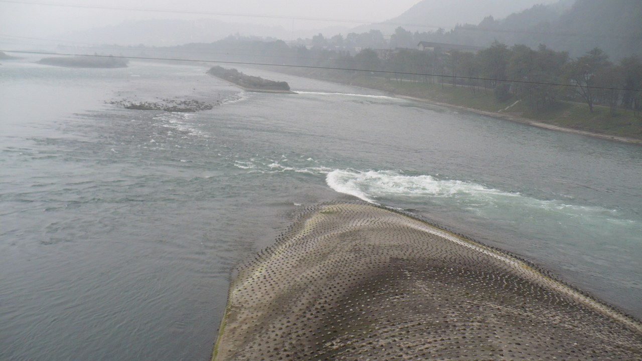
A pointed island, not a wall across the river
The Fish Mouth, or 鱼嘴, is an unexpectedly small shape to carry such a large story. In the archive photograph above, a pale point separates two stretches of water. The river has not been stopped and collected behind a monumental barrier. It has been given a choice of channels. Reading that division is a better beginning than trying to fit the entire landscape into one photograph.
Dujiangyan (都江堰) sits where the Minjiang (岷江) reaches the Chengdu plain. UNESCO dates the system’s beginnings to around 256 BCE, while describing later modifications under several dynasties. Its account identifies three cooperating elements: Yuzui, Feishayan and Baopingkou. The surviving system is therefore neither one original object nor a single clever channel. It is an arrangement that has continued through alteration and maintenance. [1]
Three structures, three different questions
Start with Yuzui, the Fish Mouth dividing levee (鱼嘴分水堤). The World Heritage nomination describes the river dividing into an outer channel and an inner channel, the latter supplying the plain through Baopingkou. The point is not simply to obtain more water. Water has to be directed into a useful route while another route remains available. [2]
Next is Feishayan (飞沙堰), the overflow and sediment-release element. A water-bureau account explains how excess flow and material can return towards the outer river rather than choking the inner route. Treat the low crossing as part of the design, not an unfinished version of a higher wall. A barrier can be useful precisely because water can pass over it under the appropriate conditions. [3]
Finally, Baopingkou (宝瓶口) is the constrained passage cut through the rock. Its name invokes a bottle’s neck. The same official account connects the cutting with the separated rock mass called Lidui (离堆). Here the useful object is an opening: a limit that helps determine how much water can move onwards. [3]
Our interpretation: division, release and constraint make a more revealing sequence than “ancient people conquered a river”. The system has several places for an unwanted outcome to go. That does not mean it works without people, repair or judgement. It means those tasks operate through a landscape whose parts have different jobs.
Do not turn “still working” into “never changed”
UNESCO calls this living heritage and stresses regular maintenance. Its historical summary explicitly records enlargement and modification. The continuing function is impressive precisely because it has required continuity of attention. Calling every visible surface 2,000 years old would replace that history with a simpler and less useful myth. [1]
The image on this page was taken in 2007. It helps identify the dividing shape, but cannot establish today’s water level, barriers, bridge condition or visitor circulation. Compare a photograph with the site’s current notices rather than expecting the scene to repeat itself. A high-water closure would be a reason to change the visit, not to pursue a more dramatic viewpoint.
The engineering also changes what counts as a satisfying photograph. One wide view may give you beauty without showing the relationships. Take a permitted overall view, then a detail of the division, and a note about where the inner channel goes. The resulting sequence can explain more than a lone image with the word “ancient” underneath it.
A focused half-day from the city-side entrance
This is a researched proposal, not a route we claim to have walked. Give the core site three to four hours as a planning allowance, plus travel and lunch. The order below begins downstream so that the final dividing point answers questions raised by the earlier stops. It is a viewing sequence, not an official guarantee that every connection is open.
- Arrange the approach. Save 都江堰景区离堆公园入口 as the meeting destination. From Chengdu, check an actual dated rail service in the official 12306 system, or arrange a road transfer with your accommodation. Do not select a station merely because its English name contains “Dujiangyan”; compare the arrival station with the entrance before paying. Confirm the final local transfer separately.
- Lidui entrance to Baopingkou — budget 45–60 minutes. Follow current signs towards the public viewpoints around Fulong Temple (伏龙观) and the bottle-neck passage. Look for the relationship between the rock mass and the narrow water route. If a building or stairway is closed, use the permitted outdoor viewpoint; access inside a temple is not essential to this question.
- Continue towards Feishayan — budget around 30 minutes. Use the marked visitor paths. Locate the low overflow area and compare its role with the narrow passage you have just seen. Ask where excess water would go. Do not descend onto river engineering surfaces or use a temporarily dry stretch as a shortcut.
- Reach the Yuzui viewing area — budget 45–60 minutes. Identify the point separating the channels. Sketch two arrows for the river’s paths and connect the inner one to the earlier stops. Read the current explanatory signs before repeating a fixed flow percentage; this article offers no measurement of the river on your day.
- Choose a return before crossing. Ask staff whether the Anlan bridge (安澜索桥) and the onward temple paths are open and suitable for your group. The core plan can return along permitted paths to Lidui. An extension towards Erwang Temple (二王庙) adds a different terrain and should depend on remaining time, steps and current circulation. It is optional, not required to complete the water story.
The provincial scenic-area planning document records city approaches through Lidui Park, but it is a planning source rather than a daily access bulletin. Use it to understand the connection, then confirm actual entrances and exits with the operator. [4]
The decisions to settle before travelling
We have not established a dated October 2026 admission tariff, train timetable or bridge-access notice from the primary records reviewed here. Confirm opening, ticketing, passport requirements, weather restrictions and the usable return route for your date. No price or exact departure is quoted as current.
For limited mobility, ask about the route surface, gradients, available transport and which viewing areas can actually be reached. “A half-day” is a time budget, not an accessibility assessment. For a short visit, keep the three water structures and omit the uphill extension. Put Mount Qingcheng (青城山) on a separate day rather than treating the shared UNESCO name as a compact walking circuit.
A Chinese brief that asks for the right visit
我们想以都江堰水利工程为重点,从离堆公园入口附近开始,重点看宝瓶口、飞沙堰和鱼嘴。请确认当天开放时间、门票及护照预约要求、步行距离和台阶、安澜索桥是否开放,以及可行的返回路线。希望讲解三处工程如何配合、后来的修缮与维护,不安排未确认开放的河道或工程区域。请单列接送、等候、讲解和门票费用。
A useful guide should be able to connect the stops, not simply supply three translations. Ask which visible parts have changed and what maintenance keeps the arrangement useful. The most interesting thing here may be how a design survives through work, rather than how long ago somebody first imagined it.
Give the detour a place in your trip
Send your date, starting neighbourhood, party size, walking needs and onward travel through our existing consultation form. Guiding, transport and personalised planning are separate services subject to confirmation. Browse the existing PDF previews before buying: this article does not announce a new Dujiangyan PDF.
Send your trip brief ↗Browse one-off PDF guides ↗For the current protected cultural dossier and its free preview, see shared membership. Membership is separate from PDFs, transport, guiding and bookings.
Preview the member deep read ↗Official sources & further reading
- UNESCO: Mount Qingcheng and the Dujiangyan Irrigation System — World Heritage account; beginnings, three components, modifications and maintenance. Checked 18 October 2026.
- World Heritage nomination dossier — Historical engineering description and channel relationships; not a present-day operating notice.
- Yangquan Water Bureau: Dujiangyan waterworks — 2 March 2026; official educational account of the dividing levee, overflow and rock-cut passage. Not the attraction’s visitor operator.
- Sichuan Forestry and Grassland Administration: detailed scenic-area plan — Posted February 2025; city-side approaches, not a live access timetable.
- China Railway 12306 — Check the actual date, station, identity requirements and bookable service.
- Colin W: Fish Mouth photograph — 26 October 2007, CC BY-SA 3.0; archive context and image licence.
